
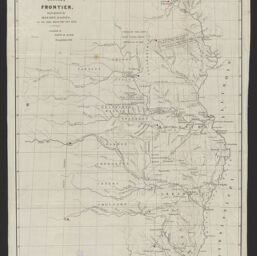
Map illustrating the plan of the defences [sic] of the Western Frontier / as prepared by Maj. Gen. Gaines in his plan dated Feb. 28th, 1838
Map of the defences [sic] of the Western Frontier
Permalink
https://digital.library.illinois.edu/items/1d8e2970-d050-013b-46a1-02d0d7bfd6e4-4
No Copyright - United States
Descriptive Information
| Title | Map illustrating the plan of the defences [sic] of the Western Frontier / as prepared by Maj. Gen. Gaines in his plan dated Feb. 28th, 1838 |
| Alternative Title | Map of the defences [sic] of the Western Frontier |
| Creator | Burr, David H., 1803-1875 |
| Scale | Scale approximately 1:3,525,000 |
| Coordinates | W 103°00ʹ--W 89°00ʹ/N 48°00'--N 29°00' |
| Date of Publication | 1838 |
| Extent | 1 map : colored |
| Dimensions | 60 x 38 cm, folded to 20 x 9 cm |
| Notes |
|
| Coverage-Spatial | |
| Language | English |
| Subject | |
| Associated Entities | Haas, Philip, active 1837-1863 |
| Genre | Maps |
| Rights | No Copyright - United States |
| Type | Cartographic material |
| Repository | Map Library |
| Local Bib ID | 99399233512205899 |
| Collection Title | Railroad Maps |
| Collection | Railroad Maps |
Download Options
|
Map illustrating the plan of the defences [sic] of the Western Frontier / as prepared by Maj. Gen. Gaines in his plan dated Feb. 28th, 1838 |
Contact us
for questions and to provide feedback.