
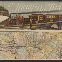
Map of the old reliable Hannibal and St. Joseph short line
Permalink
https://digital.library.illinois.edu/items/1df929d0-d050-013b-46a1-02d0d7bfd6e4-1
No Copyright - United States
Descriptive Information
| Title | Map of the old reliable Hannibal and St. Joseph short line |
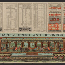
| Alternative Title | Panel title: Old reliable Hannibal and St. Joseph Rail Road, the pioneer route to the West : two through trains daily via Quincy |
| Creator | Rand McNally and Company |
| Scale | Scale approximately 1:6,810,000 |
| Coordinates | W 106°--W 69°/N 46°--N 35° |
| Place of Publication | Chicago (Ill.) |
| Publisher | Rand McNally and Company |
| Date of Publication | 1882 |
| Extent | 1 map : color |
| Dimensions | 17 x 48 cm, on sheet 36 x 53 cm, folded to 18 x 9 cm |
| Notes |
|
| Coverage-Spatial | United States |
| Language | English |
| Subject | |
| Associated Entities | Hannibal and St. Joseph Railroad Company |
| Genre | Maps |
| Rights | No Copyright - United States |
| Type | Cartographic material |
| Repository | Map Library |
| Local Bib ID | 99955216234605899 |
| Collection Title | Railroad Maps |
| Collection | Railroad Maps |
Download Options
|
99955216234605899-001 | |
|
99955216234605899-002 |
Contact us
for questions and to provide feedback.