
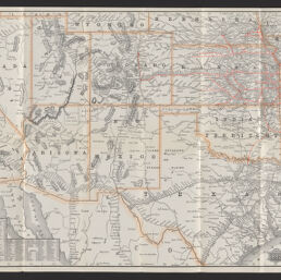
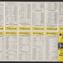
Map of the Missouri Pacific and St. Louis, Iron Mountain and Southern railways and connections
Permalink
https://digital.library.illinois.edu/items/1e2c8f80-d050-013b-46a1-02d0d7bfd6e4-9
No Copyright - United States
Descriptive Information
| Title | Map of the Missouri Pacific and St. Louis, Iron Mountain and Southern railways and connections |
| Alternative Title | Panel title: Missouri Pacific Railway : St. Louis to all points west, chair cars free, fast mail route |
| Creator | Rand McNally and Company |
| Scale | Scale approximately 1:3,735,000 |
| Place of Publication | Chicago (Ill.) |
| Publisher | Rand McNally and Company |
| Date of Publication | 1892 |
| Extent | 1 map : color |
| Dimensions | 42 x 78 cm, folded to 22 x 10 cm |
| Notes |
|
| Coverage-Spatial | United States |
| Language | English |
| Subject | |
| Genre | Maps |
| Rights | No Copyright - United States |
| Type | Cartographic material |
| Repository | Map Library |
| Local Bib ID | 99955259537305899 |
| Collection Title | Railroad Maps |
| Collection | Railroad Maps |
Download Options
|
99955259537305899-001 | |
|
99955259537305899-002 |
Contact us
for questions and to provide feedback.