
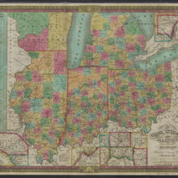
Map of the states of Ohio, Indiana and Illinois with the settled part of part of Michigan
Permalink
https://digital.library.illinois.edu/items/1e3740a0-d050-013b-46a1-02d0d7bfd6e4-4
No Copyright - United States
Descriptive Information
| Title | Map of the states of Ohio, Indiana and Illinois with the settled part of part of Michigan |
| Creator | Mitchell, S. Augustus (Samuel Augustus), 1792-1868 |
| Scale | Scale approximately. 1:2,090,880 |
| Coordinates | W 91°56ʹ00ʺ--W 80°11ʹ00ʺ/N 44°14ʹ00ʺ--N 37°57ʹ00ʺ |
| Place of Publication | Philadelphia (Pa.) |
| Publisher | Mitchell, S. Augustus (Samuel Augustus), 1792-1868 |
| Date of Publication | 1834 |
| Extent | 1 map : color |
| Dimensions | 41 x 53 cm |
| Notes |
|
| Coverage-Spatial | Middle West |
| Language | English |
| Subject | Railroads |
| Associated Entities | Young, J. H. (James Hamilton) |
| Genre | Maps |
| Rights | No Copyright - United States |
| Type | Cartographic material |
| Repository | Map Library |
| Local Bib ID | 99955259542605899 |
| Collection Title | Railroad Maps |
| Collection | Railroad Maps |
Download Options
|
Map of the states of Ohio, Indiana and Illinois with the settled part of part of Michigan |
Contact us
for questions and to provide feedback.