


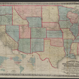
Cabinet map of the Western states and territories on a rectangular projection showing the location of gold silver and other minerals, the railroads and principal cities : the meridian lines base lines and congressional townships as far as public surveys have been extended
Cabinet map of the Western states and territories
Permalink
https://digital.library.illinois.edu/items/1e4ffaf0-d050-013b-46a1-02d0d7bfd6e4-d
No Copyright - United States
Descriptive Information
| Title | Cabinet map of the Western states and territories on a rectangular projection showing the location of gold silver and other minerals, the railroads and principal cities : the meridian lines base lines and congressional townships as far as public surveys have been extended |
| Alternative Title | Cabinet map of the Western states and territories |
| Scale | Scale 1:3,801,600 |
| Place of Publication | Chicago (Ill.) |
| Publisher | Blanchard, Rufus, 1821-1904 |
| Date of Publication | 1869 |
| Extent | 1 map : color |
| Dimensions | 79 x 103 cm (folded to 15 x 10 cm) |
| Notes |
|
| Coverage-Spatial | West (U.S.) |
| Language | English |
| Subject | |
| Associated Entities | |
| Genre | Maps |
| Rights | No Copyright - United States |
| Type | Cartographic material |
| Repository | Map Library |
| Local Bib ID | 99955259698205899 |
| Collection Title | Railroad Maps |
| Collection | Railroad Maps |
Download Options
|
Cabinet map of the Western states and territories on a rectangular projection showing the location of gold silver and other minerals, the railroads and principal cities : the meridian lines base lines and congressional townships as far as public surveys have been extended |
Contact us
for questions and to provide feedback.