
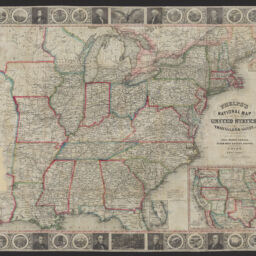
Phelps's national map of the United States : a travellers guide : embracing the principal rail roads, canals, steamboat & stage routes throughout the Union
Phelps's travelers guide through the United States
Permalink
https://digital.library.illinois.edu/items/1e789190-d050-013b-46a1-02d0d7bfd6e4-7
No Copyright - United States
Descriptive Information
| Title | Phelps's national map of the United States : a travellers guide : embracing the principal rail roads, canals, steamboat & stage routes throughout the Union |
| Alternative Title |
|
| Creator | Atwood, John M., approximately 1818- |
| Scale | Scale [ca. 1:4,752,000] |
| Place of Publication | New York (N.Y.) |
| Publisher | Ensign, Bridgeman & Fanning |
| Date of Publication | 1855 |
| Extent | 1 map : hand colored |
| Dimensions | 45 x 57 cm, folded in cover 15 x 9 cm + text (72 pages ; 15 cm) |
| Notes |
|
| Coverage-Spatial | United States |
| Language | English |
| Subject | Transportation |
| Genre | |
| Rights | No Copyright - United States |
| Type | Cartographic material |
| Repository | Map Library |
| Local Bib ID | 99955259921505899 |
| Collection Title | Railroad Maps |
| Collection | Railroad Maps |
Download Options
|
Phelps's national map of the United States : a travellers guide : embracing the principal rail roads, canals, steamboat & stage routes throughout the Union |
Contact us
for questions and to provide feedback.