


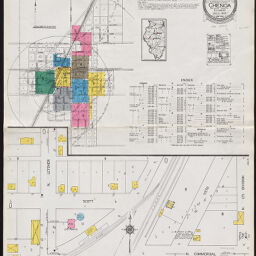
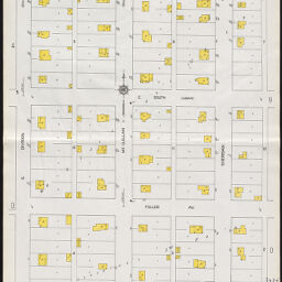
Chenoa, Mc Lean County, Illinois, July, 1923
Permalink
https://digital.library.illinois.edu/items/33b793f0-8a1f-0137-6d99-02d0d7bfd6e4-e
In the public domain.
Descriptive Information
| Title | Chenoa, Mc Lean County, Illinois, July, 1923 |
| Creator | Sanborn Map Company |
| Coverage-Spatial | Chenoa (Ill.) |
| Genre | Fire insurance maps |
| Subject | Fire risk assessment |
| Publisher | Sanborn Map & Publishing Co. |
| Date of Publication | 1923 |
| Place of Publication | New York (N.Y.) |
| Scale | [ca. 1:600] |
| Language | English |
| Notes |
|
| Extent | 9 maps : color |
| Dimensions | 65 x 55 cm |
| Coordinates | W 88⁰43ʹ11ʺ/N 40⁰44ʹ30ʺ |
| Rights | No Copyright - United States |
| Rights Description | In the public domain. |
| Type | Cartographic material |
| Repository | Map Library |
| Local Bib ID | 1624761 |
| Collection Title | Sanborn Fire Insurance Maps |
| Collection | Sanborn Fire Insurance Maps |
Download Options
|
1923_Page_01 | |

|
1923_Page_02 | |

|
1923_Page_03 | |

|
1923_Page_04 | |

|
1923_Page_05 | |

|
1923_Page_06 | |

|
1923_Page_07 | |
|
1923_Page_08 | |

|
1923_Page_09 |
Contact us
for questions and to provide feedback.