
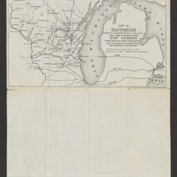
Map of Wisconsin shewing the location of rail roads finished and projected, with a table of distances from New London to the principal towns in the state, also the principal navigable waters that contribute to its commerce
Permalink
https://digital.library.illinois.edu/items/348c8610-9868-013c-4aba-02d0d7bfd6e4-2
No Copyright - United States
Descriptive Information
| Title | Map of Wisconsin shewing the location of rail roads finished and projected, with a table of distances from New London to the principal towns in the state, also the principal navigable waters that contribute to its commerce |
| Alternative Title | Map of Wisconsin showing the location of railroads finished and projected, with a table of distances from New London to the principal towns in the state, also the principal navigable waters that contribute to its commerce |
| Creator | Lipmoor, L. |
| Coordinates | W 92°53ʹ--W 86°14ʹ/N 47°18ʹ--N 42°29ʹ |
| Place of Publication | New London (Wis.) |
| Date of Publication | 1862 |
| Extent | 1 map |
| Dimensions | 19 x 24 cm, on sheet 40 x 25 cm |
| Notes |
|
| Coverage-Spatial | |
| Language | English |
| Subject | Railroads |
| Genre | Maps |
| Rights | No Copyright - United States |
| Type | Cartographic material |
| Repository | Map Library |
| Local Bib ID | 99955481323505899 |
| Collection Title | Railroad Maps |
| Collection | Railroad Maps |
Download Options

|
99955481323505899-001 | |
|
99955481323505899-002 |
Contact us
for questions and to provide feedback.