
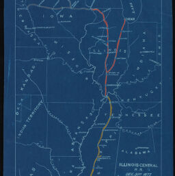
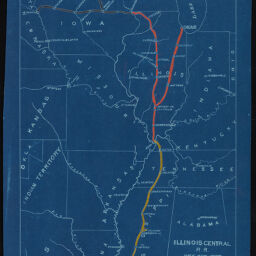
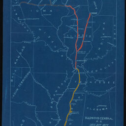
Illinois Central Railroad blueprint map: New Orleans to Chicago
Permalink
https://digital.library.illinois.edu/items/450da900-0851-0136-4c64-0050569601ca-8
This item is in the public domain.
Descriptive Information
| Title | Illinois Central Railroad blueprint map: New Orleans to Chicago |
| Date | 1877 |
| Decade | 1870s |
| Description | A map of the Illinois Central Railroad displaying route from New Orleans, Louisiana to Chicago, Illinois. This map is dated December 31, 1877. 7 copies. |
| Dimensions | 33.9 cm x 20.5 cm |
| Subject | Transportation |
| Genre | Maps |
| Geographic coverage | Illinois |
| Language | English |
| Local Identifier | 0418_0188_01 |
| Rights | No Copyright - United States |
| Rights Description | This item is in the public domain. |
| Repository | Illinois History and Lincoln Collections |
| Collection Title | IHLC Collection of Illinois and U.S. History Broadsides and Printed Ephemera |
| Type | Text |
| Collection | Illinois and US History Broadsides and Printed Ephemera Collection (Digitized Content) |
Download Options
|
0418_0188_01-001 | |

|
0418_0188_01-002 | |
|
0418_0188_01-003 | |

|
0418_0188_01-004 | |

|
0418_0188_01-005 | |

|
0418_0188_01-006 | |

|
0418_0188_01-007 | |

|
0418_0188_01-008 | |

|
0418_0188_01-009 | |

|
0418_0188_01-010 | |

|
0418_0188_01-011 | |

|
0418_0188_01-012 | |
|
0418_0188_01-013 | |

|
0418_0188_01-014 |
Contact us
for questions and to provide feedback.