
Survey of Mississippi River atlas
Permalink
https://digital.library.illinois.edu/items/4be540f0-9792-0137-6ddc-02d0d7bfd6e4-7
No Copyright - United States
Descriptive Information
| Title | Survey of Mississippi River atlas |
| Alternative Title |
|
| Creator | Board on Examination and Survey of Mississippi River (U.S.) |
| Place of Publication | Washington (D.C.) |
| Publisher | United States. Government Printing Office |
| Date of Publication | 1909 |
| Extent | 52 plates on 104 leaves |
| Dimensions | 64 cm |
| Notes |
|
| Coverage-Spatial | Mississippi River |
| Language | English |
| Subject | Hydrographic surveying |
| Genre | Maps |
| Volume | Vol. 2 |
| Rights | No Copyright - United States |
| Type | Cartographic material |
| Repository | Map Library |
| Local Bib ID | 872957 |
| Collection Title | River Maps |
| Collection | River Maps |
Download Options
|
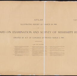
Title Page | |

|
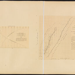
Plate 1 | |
|
Plate 2 | |

|
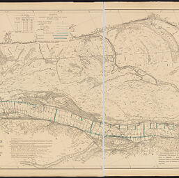
Plate 3 | |

|
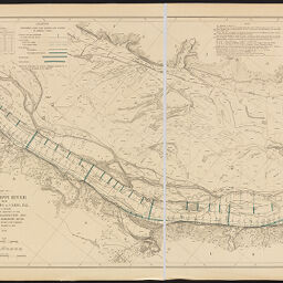
Plate 4 | |
|
Plate 5 | |
|
Plate 6 | |
|
Plate 7 | |

|
Plate 8 | |

|
Plate 9 | |

|
Plate 10 | |
|
Plate 11 | |

|
Plate 12 | |
|
Plate 13 | |
|
Plate 14 | |
|
Plate 15 | |
|
Plate 16 | |
|
Plate 17 | |

|
Plate 18 | |
|
Plate 19 | |

|
Plate 20 | |
|
Plate 21 | |

|
Plate 22 | |
|
Plate 23 | |
|
Plate 24 | |
|
Plate 25 | |

|
Plate 26 | |

|
Plate 27 | |
|
Plate 28 | |

|
Plate 29 | |

|
Plate 30 | |

|
Plate 31 | |

|
Plate 32 | |
|
Plate 33 | |

|
Plate 34 | |
|
Plate 35 | |
|
Plate 36 | |

|
Plate 37 | |

|
Plate 38 | |

|
Plate 39 | |
|
Plate 40 | |
|
Plate 41 | |
|
Plate 42 | |
|
Plate 43 | |

|
Plate 44 | |
|
Plate 45 | |
|
Plate 46 | |
|
Plate 47 | |
|
Plate 48 | |
|
Plate 49 | |
|
Plate 50 | |

|
Plate 51 | |
|
Plate 52 |
Contact us
for questions and to provide feedback.