
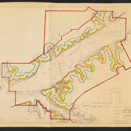
Robert Allerton Park : Land Acquisition & Flood Frequency Map
Permalink
https://digital.library.illinois.edu/items/57b2bcb0-b753-0139-78e9-02d0d7bfd6e4-5
Copyright Not Evaluated
Descriptive Information
| Title | Robert Allerton Park : Land Acquisition & Flood Frequency Map |
| Creator | Vick, B. |
| County | Piatt County |
| Country | United States |
| State | Illinois |
| Subject | Floods |
| Genre | Maps |
| Date | 1967-1979 |
| Scale | Scale 1:4,800. 1" = 400' |
| Description | Flood frequency shown by numbered contours. Likely published between July 1967 and 1979. |
| Rights | Copyright Not Evaluated |
| Extent | 72 x 103 cm |
| Type | Cartographic material |
| Repository | Map Library |
| Resource Identifier | 99954855502605899 |
| Collection Title | Allerton Park Maps and Air Photos |
| Collection | Allerton Park Maps and Air Photos |
Download Options
|
Robert Allerton Park : Land Acquisition & Flood Frequency Map |
Contact us
for questions and to provide feedback.