
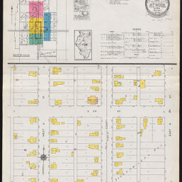
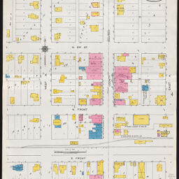
Atwood, Douglas & Piatt counties, Illinois, May, 1923
Permalink
https://digital.library.illinois.edu/items/72a999f0-e748-0135-4ad8-0050569601ca-8
In the public domain.
Descriptive Information
| Title | Atwood, Douglas & Piatt counties, Illinois, May, 1923 |
| Creator | Sanborn Map Company |
| Coverage-Spatial | Atwood (Ill.) |
| Genre | Fire insurance maps |
| Subject | Fire risk assessment |
| Publisher | Sanborn Map & Publishing Co. |
| Date of Publication | 1923 |
| Place of Publication | New York (N.Y.) |
| Scale | Scale ca. 1:600. |
| Language | English |
| Notes |
|
| Extent | 4 maps : color |
| Dimensions | 65 x 55 cm |
| Coordinates | (W 88°27ʹ44ʺ/N 39°47ʹ58ʺ) |
| Rights | No Copyright - United States |
| Rights Description | In the public domain. |
| Type | Cartographic material |
| Repository | Map Library |
| Local Bib ID | 7319063 |
| Collection Title | Sanborn Fire Insurance Maps |
| Collection | Sanborn Fire Insurance Maps |
Download Options
|
1923_Page001 | |
|
1923_Page002 | |

|
1923_Page003 | |

|
1923_Page004 |
Contact us
for questions and to provide feedback.