
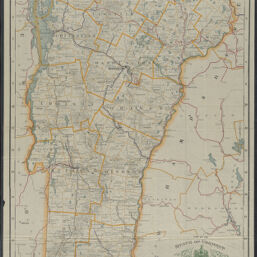
Map of the State of Vermont
Permalink
https://digital.library.illinois.edu/items/72fae6c0-bcd3-013e-35f7-02d0d7bfd6e4-3
This item is in the public domain.
Descriptive Information
| Title | Map of the State of Vermont |
| Creator | Cram, George Franklin, 1841-1928 |
| Contributor | Vermont. Public Service Commission |
| Scale | Scale ca. 1:250,000 |
| Coordinates | (W 73°26ʹ--W 71°28ʹ/N 45°00ʹ--N 42°43ʹ) |
| Place of Publication | Chicago (Ill.) |
| Publisher | George F. Cram Company |
| Date of Publication | 1910 |
| Extent | 1 map : color, mounted on linen |
| Dimensions | 109 x 66 cm |
| Notes |
|
| Coverage-Spatial | Vermont |
| Language | English |
| Subject | Railroads |
| Associated Entities | Vermont. Public Service Commission |
| Genre | |
| Rights | No Copyright - United States |
| Rights Description | This item is in the public domain. |
| Type | Cartographic material |
| Repository | Map Library |
| Local Bib ID | 99161493612205899 |
| Collection Title | Railroad Maps |
| Collection | Railroad Maps |
Download Options
|
99161493612205899-00000001 | |
|
99161493612205899-00000002 |
Contact us
for questions and to provide feedback.