
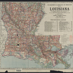
The Department of Agriculture and Immigration's map of Louisiana : showing parishes, parish seats, cities, towns, villages, etc., railroads, with distances between stations, the state highway system, improved and proposed improved roads
Permalink
https://digital.library.illinois.edu/items/73bdd7d0-bcd3-013e-35f7-02d0d7bfd6e4-d
This item is in the public domain.
Descriptive Information
| Title | The Department of Agriculture and Immigration's map of Louisiana : showing parishes, parish seats, cities, towns, villages, etc., railroads, with distances between stations, the state highway system, improved and proposed improved roads |
| Alternative Title | Map of Louisiana |
| Creator | Louisiana. Department of Agriculture and Immigration |
| Scale | Scale [ca. 1:865,000] |
| Place of Publication | Indianapolis (Ind.) |
| Publisher | George F. Cram Company |
| Date of Publication | 1929 |
| Extent | 1 map : color |
| Dimensions | 52 x 58 cm |
| Notes |
|
| Coverage-Spatial | Louisiana |
| Language | English |
| Subject | |
| Genre | Maps |
| Rights | No Copyright - United States |
| Rights Description | This item is in the public domain. |
| Type | Cartographic material |
| Repository | Map Library |
| Local Bib ID | 99955700454805899 |
| Collection Title | Railroad Maps |
| Collection | Railroad Maps |
Download Options
|
99955700454805899-00000001 | |

|
99955700454805899-00000002 |
Contact us
for questions and to provide feedback.