
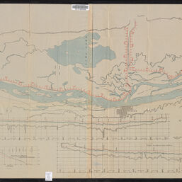
Map of survey along the east bank of the Mississippi River from the city of Warsaw to the city of Quincy with a view to improving the navigation by preventing the water from overflowing the natural and artificial banks along those parts of the river and deepening the channel as express in the River and Harbor Act of Aug. 17. 1894. Shows profile and alignment of the Hunt, Lima Lake, and Indian Grave levees, and estimate of cost of reinforcing same. Compiled from surveys of the Mississippi River Commission and actual measurements. Made under direction of A. Mackenzie, Major of Engineers, U. S. Army, by M. Meigs, U. S. C. E. and R. Monroe, surveyor
Permalink
https://digital.library.illinois.edu/items/8b228910-d675-0137-6f52-02d0d7bfd6e4-f
No Copyright - United States
Descriptive Information
| Title | Map of survey along the east bank of the Mississippi River from the city of Warsaw to the city of Quincy with a view to improving the navigation by preventing the water from overflowing the natural and artificial banks along those parts of the river and deepening the channel as express in the River and Harbor Act of Aug. 17. 1894. Shows profile and alignment of the Hunt, Lima Lake, and Indian Grave levees, and estimate of cost of reinforcing same. Compiled from surveys of the Mississippi River Commission and actual measurements. Made under direction of A. Mackenzie, Major of Engineers, U. S. Army, by M. Meigs, U. S. C. E. and R. Monroe, surveyor |
| Creator | United States. Army. Corps of Engineers |
| Contributor | |
| Scale | 1:40,000 |
| Place of Publication | Washington (D.C.) |
| Publisher | The Norris Peters Co. |
| Date of Publication | 1894 |
| Extent | 1 map |
| Dimensions | 50 x 149 cm |
| Notes |
|
| Coverage-Spatial | Mississippi River |
| Language | English |
| Subject | Levees |
| Genre | Maps |
| Rights | No Copyright - United States |
| Type | Cartographic material |
| Repository | Map Library |
| Local Bib ID | 7148157 |
| Collection Title | River Maps |
| Collection | River Maps |
Download Options
|
Map of survey along the east bank of the Mississippi River from the city of Warsaw to the city of Quincy with a view to improving the navigation by preventing the water from overflowing the natural and artificial banks along those parts of the river and deepening the channel as express in the River and Harbor Act of Aug. 17. 1894. Shows profile and alignment of the Hunt, Lima Lake, and Indian Grave levees, and estimate of cost of reinforcing same. Compiled from surveys of the Mississippi River Commission and actual measurements. Made under direction of A. Mackenzie, Major of Engineers, U. S. Army, by M. Meigs, U. S. C. E. and R. Monroe, surveyor |
Contact us
for questions and to provide feedback.