The items in the Digital Collections of the University of Illinois Urbana-Champaign Library contain materials which represent or depict sensitive topics or were written from perspectives using outdated or biased language. The Library condemns discrimination and hatred on any grounds. As a research library that supports the mission and values of this land grant institution, it is incumbent upon the University Library to preserve, describe, and provide access to materials to accurately document our past, support learning about it, and effect change in the present. In accordance with the American Library Association’s Freedom to Read statement, we do not censor our materials or prevent patrons from accessing them.
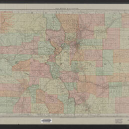
Rand, McNally & Co.'s Colorado Cover title: Rand-McNally indexed county and township pocket map and shippers' guide of Colorado : showing all railroads, cities, towns, villages, postoffices, lakes, rivers, etc., corrected to date
Cover title: Rand-McNally indexed county and township pocket map and shippers' guide of Colorado : showing all railroads, cities, towns, villages, postoffices, lakes, rivers, etc., corrected to date
Title at foot of map: Rand, McNally & Co.'s New Business Atlas Map of Colorado
Overprint title: Colorado railroads
Creator
Rand McNally and Company
Scale
Scale [1:1,013,760]. 1 in. to 16 miles
Coordinates
W 109°--W 102°/N 41°--N 37°
Place of Publication
Chicago (Ill.)
Publisher
Rand McNally and Company
Date of Publication
1911
Extent
1 map : color
Dimensions
47 x 65 cm, folded in cover 17 x 11 cm + index attached in cover (62 pages : illustrations ; 17 cm)
Notes
Index attached to cover includes explanation of abbreviations; numbered list of railroads; index to electric lines; indexes to counties, a variety of water and other physical features, towns; list of United States land offices in all states and territories, advertisements for Rand McNally publications and products, advertisements for Colorado businesses (primarily hotels), and index to advertisements.
Supplemental copyright statement: Copyright, 1904, by Rand, McNally & Co.
Numbered list of 33 railroads overprinted in red.
Index to principal cities in left margin.
Shows railroads including electric lines, towns, surface water, counties, and townships.