
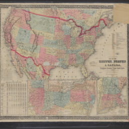
Goldthwaite's map of the United States & Canada : exhibiting the railroads with their distances, single and double track & width of gauge : and the time compared with noon at Washington and Greenwich
Permalink
https://digital.library.illinois.edu/items/8d3fa770-9b55-013c-4aba-02d0d7bfd6e4-1
No Copyright - United States
Descriptive Information
| Title | Goldthwaite's map of the United States & Canada : exhibiting the railroads with their distances, single and double track & width of gauge : and the time compared with noon at Washington and Greenwich |
| Creator | Goldthwait, J. H. |
| Scale | Scale approximately 1:7,500,000 |
| Coordinates | W 129°--W 57°/N 53°--N 22° |
| Place of Publication | New York (N.Y.) |
| Publisher | G.Q. Colton, 1861 |
| Extent | 1 map : color |
| Dimensions | 77 x 45 cm, on sheet 73 x 84 cm, folded in cover 28 x 23 cm |
| Notes |
|
| Coverage-Spatial | |
| Language | English |
| Subject | Railroads |
| Genre | Maps |
| Rights | No Copyright - United States |
| Type | Cartographic material |
| Repository | Map Library |
| Local Bib ID | 99442093612205899 |
| Collection Title | Railroad Maps |
| Collection | Railroad Maps |
Download Options
|
Goldthwaite's map of the United States & Canada : exhibiting the railroads with their distances, single and double track & width of gauge : and the time compared with noon at Washington and Greenwich |
Contact us
for questions and to provide feedback.