
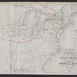
Map of the various channels for conveying the trade of the north west to the Atlantic sea-board exhibiting the tributaries & drainage of the trade into each and the effect of the enlargement of the Erie Canal, illustrating the position taken by William J. McAlpine, C.E. in his Annual Report as State Engineer and Surveyor of the State of New York, 1853
Permalink
https://digital.library.illinois.edu/items/8d73e660-9b55-013c-4aba-02d0d7bfd6e4-5
No Copyright - United States
Descriptive Information
| Title | Map of the various channels for conveying the trade of the north west to the Atlantic sea-board exhibiting the tributaries & drainage of the trade into each and the effect of the enlargement of the Erie Canal, illustrating the position taken by William J. McAlpine, C.E. in his Annual Report as State Engineer and Surveyor of the State of New York, 1853 |
| Creator | Vaughan, David, active 1849-1864 |
| Scale | Scale approximately 1:3,800,000 |
| Place of Publication | Albany (N.Y.) |
| Publisher | Gavit, J.E. |
| Date of Publication | 1853 |
| Extent | 1 map : hand color |
| Dimensions | 50 x 65 cm |
| Notes |
|
| Coverage-Spatial | |
| Language | English |
| Subject | |
| Genre | Maps |
| Rights | No Copyright - United States |
| Type | Cartographic material |
| Repository | Map Library |
| Local Bib ID | 99955350108205899 |
| Collection Title | Railroad Maps |
| Collection | Railroad Maps |
Download Options
|
Map of the various channels for conveying the trade of the north west to the Atlantic sea-board exhibiting the tributaries & drainage of the trade into each and the effect of the enlargement of the Erie Canal, illustrating the position taken by William J. McAlpine, C.E. in his Annual Report as State Engineer and Surveyor of the State of New York, 1853 |
Contact us
for questions and to provide feedback.