
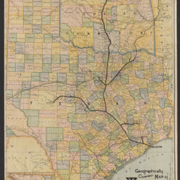
Santa Fé route : geographically correct map of Texas & Indian Territory showing lines of the Gulf, Colorado & Santa Fé Ry. and connections
Geographically correct map of Texas & Indian Territory showing lines of the Gulf, Colorado & Santa Fé Ry. and connections
Permalink
https://digital.library.illinois.edu/items/8d8f1cc0-9b55-013c-4aba-02d0d7bfd6e4-5
No Copyright - United States
Descriptive Information
| Title | Santa Fé route : geographically correct map of Texas & Indian Territory showing lines of the Gulf, Colorado & Santa Fé Ry. and connections |
| Alternative Title | Geographically correct map of Texas & Indian Territory showing lines of the Gulf, Colorado & Santa Fé Ry. and connections |
| Creator | Matthews-Northrup Company |
| Scale | Scale 1:1,520,640. 24 miles to the inch |
| Coordinates | W108°00ʹ--W 93°45ʹ/N 37°00ʹ--N 26°45ʹ |
| Place of Publication | Buffalo (N.Y.) |
| Publisher | Matthews-Northrup Company |
| Date of Publication | 1887 |
| Extent | 1 map : color |
| Dimensions | 83 x 59 cm |
| Notes |
|
| Coverage-Spatial | |
| Language | English |
| Subject | Railroads |
| Genre | Maps |
| Rights | No Copyright - United States |
| Type | Cartographic material |
| Repository | Map Library |
| Local Bib ID | 99955478706505899 |
| Collection Title | Railroad Maps |
| Collection | Railroad Maps |
Download Options
|
Santa Fé route : geographically correct map of Texas & Indian Territory showing lines of the Gulf, Colorado & Santa Fé Ry. and connections |
Contact us
for questions and to provide feedback.