
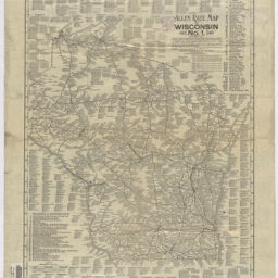
Allen rate map of Wisconsin, no. 1
Permalink
https://digital.library.illinois.edu/items/8f798b70-04a0-013c-47d9-02d0d7bfd6e4-2
No Copyright - United States
Descriptive Information
| Title | Allen rate map of Wisconsin, no. 1 |
| Creator | Schrowang, O. |
| Scale | Scale 1:1,013,760. Statute miles, 16 = 1 inch |
| Coordinates | W 92°53ʹ--W 86°14ʹ/N 47°18ʹ--N 42°29ʹ |
| Place of Publication | Saint Louis (Mo.) |
| Publisher | Allen Rate Map Co. |
| Date of Publication | 1902 |
| Extent | 1 map |
| Dimensions | 60 x 46 cm |
| Notes |
|
| Coverage-Spatial | Wisconsin |
| Language | English |
| Subject | |
| Associated Entities | Allen Rate Map Co. |
| Genre | |
| Rights | No Copyright - United States |
| Type | Cartographic material |
| Repository | Map Library |
| Local Bib ID | 99955195925805899 |
| Collection Title | Railroad Maps |
| Collection | Railroad Maps |
Download Options
|
99955195925805899-001 | |
|
99955195925805899-002 |
Contact us
for questions and to provide feedback.