
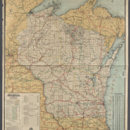
Official railroad map of Wisconsin, 1904
Permalink
https://digital.library.illinois.edu/items/8f82f180-04a0-013c-47d9-02d0d7bfd6e4-d
No Copyright - United States
Descriptive Information
| Title | Official railroad map of Wisconsin, 1904 |
| Creator | Thomas, John W., 1846-1925 |
| Scale | Scale 1:633,600. 1 in. = 10 miles |
| Coordinates | W 93°30ʹ--W 86°35ʹ/N 47°40ʹ--N 41°45ʹ |
| Place of Publication | Milwaukee (Wis.) |
| Publisher | Wm. R. Knell Publishing Co. |
| Date of Publication | 1904 |
| Extent | 1 map : color |
| Dimensions | 105 x 85 cm |
| Notes |
|
| Coverage-Spatial | Wisconsin |
| Language | English |
| Subject | Railroads |
| Associated Entities | |
| Genre | |
| Rights | No Copyright - United States |
| Type | Cartographic material |
| Repository | Map Library |
| Local Bib ID | 99955200526205899 |
| Collection Title | Railroad Maps |
| Collection | Railroad Maps |
Download Options
|
Official railroad map of Wisconsin, 1904 |
Contact us
for questions and to provide feedback.