
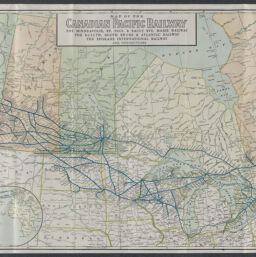
Map of the Canadian Pacific Railway : the Minneapolis, St. Paul & Sault Ste. Marie Railway, the Duluth, South Shore & Atlantic Railway, the Spokane International Railway, and connections
Permalink
https://digital.library.illinois.edu/items/8fa89eb0-04a0-013c-47d9-02d0d7bfd6e4-6
No Copyright - United States
Descriptive Information
| Title | Map of the Canadian Pacific Railway : the Minneapolis, St. Paul & Sault Ste. Marie Railway, the Duluth, South Shore & Atlantic Railway, the Spokane International Railway, and connections |
| Creator | Poole Brothers |
| Scale | Scale approximately 1:4,680,000 |
| Coordinates | W 135°--W 53°/N 60°--N 37° |
| Place of Publication | Chicago (Ill.) |
| Publisher | Poole Brothers |
| Date of Publication | 1926 |
| Extent | 1 map : color |
| Dimensions | 46 x 111 cm |
| Notes |
|
| Coverage-Spatial | |
| Language | English |
| Subject | |
| Associated Entities | Canadian Pacific Railway Company |
| Genre | Maps |
| Rights | No Copyright - United States |
| Type | Cartographic material |
| Repository | Map Library |
| Local Bib ID | 99955308325505899 |
| Collection Title | Railroad Maps |
| Collection | Railroad Maps |
Download Options
|
Map of the Canadian Pacific Railway : the Minneapolis, St. Paul & Sault Ste. Marie Railway, the Duluth, South Shore & Atlantic Railway, the Spokane International Railway, and connections |
Contact us
for questions and to provide feedback.