
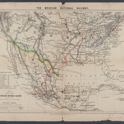
Map of the Mexican National Railway : showing also its relative position to the railway system of the United States, both as to the eastern & western halves of the continent
1882 map of the Mexican National Railway
Permalink
https://digital.library.illinois.edu/items/acabb5a0-2fac-013a-7ba8-02d0d7bfd6e4-1
No Copyright - United States
Descriptive Information
| Title | Map of the Mexican National Railway : showing also its relative position to the railway system of the United States, both as to the eastern & western halves of the continent |
| Alternative Title |
|
| Creator | Edward Stanford Ltd. |
| Scale | Scale approximately 1:8,200,000 |
| Coordinates | (W 125°--W 70°/N 45°--N 15°). |
| Place of Publication | London (England) |
| Publisher | Edward Stanford Ltd. |
| Date of Publication | 1882 |
| Extent | 1 map : color |
| Dimensions | 41 x 56 cm |
| Notes |
|
| Coverage-Spatial | |
| Language | English |
| Subject | Railroads |
| Genre | Maps |
| Rights | No Copyright - United States |
| Type | Cartographic material |
| Repository | Map Library |
| Local Bib ID | 99954784371005899 |
| Collection Title | Railroad Maps |
| Collection | Railroad Maps |
Download Options
|
Map of the Mexican National Railway : showing also its relative position to the railway system of the United States, both as to the eastern & western halves of the continent |
Contact us
for questions and to provide feedback.