
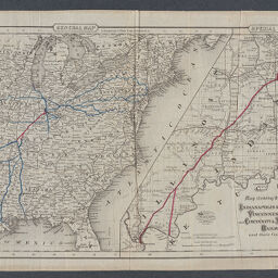
Map showing the lines of the Indianapolis & Vincennes, Vincennes & Cairo, and Cincinnati & Martinsville railways and their connections
Map showing the lines of the Indianapolis and Vincennes, Vincennes and Cairo, and Cincinnati and Martinsville railways and their connections
Permalink
https://digital.library.illinois.edu/items/acbb3760-2fac-013a-7ba8-02d0d7bfd6e4-8
No Copyright - United States
Descriptive Information
| Title | Map showing the lines of the Indianapolis & Vincennes, Vincennes & Cairo, and Cincinnati & Martinsville railways and their connections |
| Alternative Title | Map showing the lines of the Indianapolis and Vincennes, Vincennes and Cairo, and Cincinnati and Martinsville railways and their connections |
| Creator | G.W. & C.B. Colton & Co. |
| Scale | |
| Coordinates |
|
| Place of Publication | New York (N.Y.) |
| Publisher | G.W. & C.B. Colton & Co. |
| Date of Publication | 1870 |
| Extent | 2 maps on 1 sheet : color |
| Dimensions | 29 x 35 cm and 28 x 26 cm, on sheet 34 x 46 cm |
| Notes |
|
| Coverage-Spatial | |
| Language | English |
| Subject | |
| Genre | Maps |
| Rights | No Copyright - United States |
| Type | Cartographic material |
| Repository | Map Library |
| Local Bib ID | 99954879587805899 |
| Collection Title | Railroad Maps |
| Collection | Railroad Maps |
Download Options
|
Map showing the lines of the Indianapolis & Vincennes, Vincennes & Cairo, and Cincinnati & Martinsville railways and their connections |
Contact us
for questions and to provide feedback.