


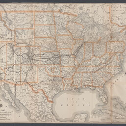
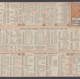
Map of the Chicago & Alton R.R. and connecting lines
Permalink
https://digital.library.illinois.edu/items/acc12980-2fac-013a-7ba8-02d0d7bfd6e4-6
No Copyright - United States
Descriptive Information
| Title | Map of the Chicago & Alton R.R. and connecting lines |
| Alternative Title |
|
| Creator | Rand McNally and Company |
| Place of Publication | Chicago (Ill.) |
| Publisher | Rand McNally and Company |
| Date of Publication | 1898 |
| Extent | 1 map : |
| Dimensions | 61 x 89 cm |
| Notes |
|
| Coverage-Spatial | United States |
| Language | English |
| Subject | |
| Genre | Maps |
| Rights | No Copyright - United States |
| Type | Cartographic material |
| Repository | Map Library |
| Local Bib ID | 99954918018805899 |
| Collection Title | Railroad Maps |
| Collection | Railroad Maps |
Download Options
|
99954918018805899-001 | |
|
99954918018805899-002 |
Contact us
for questions and to provide feedback.