
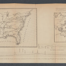
Map of the country between the Atlantic & Pacific oceans : included within the latidudes 25 & 42 & the longitudes 75 & 123 west, shewing the proposed route of a rail road from the Mississippi Valley to the ports of St. Diego, Monterey, & St. Francisco on the Pacific coast, also the connection of this road with those of the Atlantic states leading west as far as the Mississippi
Permalink
https://digital.library.illinois.edu/items/acca2850-2fac-013a-7ba8-02d0d7bfd6e4-8
No Copyright - United States
Descriptive Information
| Title | Map of the country between the Atlantic & Pacific oceans : included within the latidudes 25 & 42 & the longitudes 75 & 123 west, shewing the proposed route of a rail road from the Mississippi Valley to the ports of St. Diego, Monterey, & St. Francisco on the Pacific coast, also the connection of this road with those of the Atlantic states leading west as far as the Mississippi |
| Alternative Title | Map of the country between the Atlantic and Pacific oceans |
| Creator | Mills, Robert, 1781-1855 |
| Scale | Scale approximately 1:13,000,000 |
| Coordinates | (W 126°--W 66°/N 46°--N 23°). |
| Place of Publication | Washington (D.C.) |
| Publisher | United States. Congress. Senate |
| Date of Publication | 1852 |
| Extent | 1 map |
| Dimensions | 20 x 42 cm, on sheet 30 x 87 cm + 1 text (23 cm) |
| Notes |
|
| Coverage-Spatial | |
| Language | English |
| Subject | |
| Genre | Maps |
| Rights | No Copyright - United States |
| Type | Cartographic material |
| Repository | Map Library |
| Local Bib ID | 99954925131105899 |
| Collection Title | Railroad Maps |
| Collection | Railroad Maps |
Download Options
|
99954925131105899-001 | |

|
99954925131105899-002 | |

|
99954925131105899-003 | |

|
99954925131105899-004 | |
|
99954925131105899-005 | |

|
99954925131105899-006 | |

|
99954925131105899-007 | |

|
99954925131105899-008 | |
|
99954925131105899-009 | |
|
99954925131105899-010 | |
|
99954925131105899-011 |
Contact us
for questions and to provide feedback.