


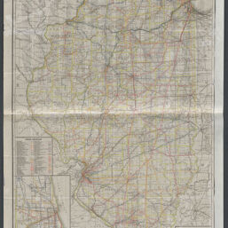
Railroad map of Illinois, 1927
Permalink
https://digital.library.illinois.edu/items/b03606f0-b51d-013a-c3e8-02d0d7bfd6e4-a
No Copyright - United States
Descriptive Information
| Title | Railroad map of Illinois, 1927 |
| Creator | Illinois Commerce Commission |
| Contributor | Rand McNally and Company |
| Scale | Scale [1:506,880]. 8 miles to 1 in. |
| Coordinates | (W 91°45ʹ--W 87°15ʹ/N 42°38ʹ--N 37°00ʹ) |
| Place of Publication | Springfield (Ill.) |
| Publisher | Illinois Commerce Commission |
| Date of Publication | 1927 |
| Extent | 1 map : color |
| Dimensions | 124 x 78 cm folded to 19 x 12 cm |
| Notes |
|
| Coverage-Spatial | Illinois |
| Language | English |
| Subject | |
| Genre | Maps |
| Rights | No Copyright - United States |
| Type | Cartographic material |
| Repository | Map Library |
| Local Bib ID | 99160684212205899 |
| Collection Title | Railroad Maps |
| Collection | Railroad Maps |
Download Options
|
99160684212205899-00000001 | |
|
99160684212205899-00000002 |
Contact us
for questions and to provide feedback.