
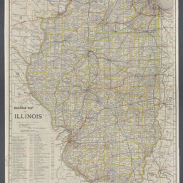
Railroad map of Illinois / prepared under the direction of, and presented by Orville F. Berry, B.A. Eckhart, Jas. A. Willoughby, Railroad and Warehouse Commissioners
Permalink
https://digital.library.illinois.edu/items/b08b9b00-b51d-013a-c3e8-02d0d7bfd6e4-5
No Copyright - United States
Descriptive Information
| Title | Railroad map of Illinois / prepared under the direction of, and presented by Orville F. Berry, B.A. Eckhart, Jas. A. Willoughby, Railroad and Warehouse Commissioners |
| Alternative Title | Railroad Commissioners' official map of Illinois |
| Creator | Rand McNally and Company |
| Contributor | Illinois. Railroad and Warehouse Commission |
| Scale | Scale [1:633,600]. 1 in. = 10 mi. |
| Coordinates | (W 91°30ʹ--W 87°30ʹ/N 42°30ʹ--N 37°00ʹ) |
| Place of Publication | Chicago (Ill.) |
| Publisher | Rand McNally and Company |
| Date of Publication | 1911 |
| Extent | 1 map : color |
| Dimensions | 95 x 62 cm, folded in cover to 17 x 10 cm |
| Notes |
|
| Coverage-Spatial | Illinois |
| Language | English |
| Subject | Railroads |
| Genre | Maps |
| Rights | No Copyright - United States |
| Type | Cartographic material |
| Repository | Map Library |
| Local Bib ID | 99162320812205899 |
| Collection Title | Railroad Maps |
| Collection | Railroad Maps |
Download Options
|
99162320812205899-00000001 | |
|
99162320812205899-00000002 |
Contact us
for questions and to provide feedback.