
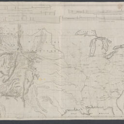
Map and profile sections showing the railroads of the United States, the several projected railways to the Pacific and thier [sic] connections, exhibiting the lines of the States, and the natural features of the cuontry [sic], from the Mississippi to the Pacific / from the latest official authorities, furnished from the Office of the Topographical Bureau at Washington ; drawn and lithograhped [sic] by Julius Hutawa
Permalink
https://digital.library.illinois.edu/items/b0bd9790-b51d-013a-c3e8-02d0d7bfd6e4-e
No Copyright - United States
Descriptive Information
| Title | Map and profile sections showing the railroads of the United States, the several projected railways to the Pacific and thier [sic] connections, exhibiting the lines of the States, and the natural features of the cuontry [sic], from the Mississippi to the Pacific / from the latest official authorities, furnished from the Office of the Topographical Bureau at Washington ; drawn and lithograhped [sic] by Julius Hutawa |
| Creator | Loughborough, J. (John) |
| Contributor | Hutawa, Julius |
| Scale | Scale approximately 1:5,400,000 |
| Place of Publication | Saint Louis (Mo.) |
| Publisher | Loughborough, J. (John) |
| Date of Publication | 1849 |
| Extent | 1 map |
| Dimensions | 27 x 42 cm |
| Notes |
|
| Coverage-Spatial | United States |
| Language | English |
| Subject | Railroads |
| Genre | |
| Rights | No Copyright - United States |
| Type | Cartographic material |
| Repository | Map Library |
| Local Bib ID | 99398858912205899 |
| Collection | Railroad Maps |
Download Options
|
Map and profile sections showing the railroads of the United States, the several projected railways to the Pacific and thier [sic] connections, exhibiting the lines of the States, and the natural features of the cuontry [sic], from the Mississippi to the Pacific / from the latest official authorities, furnished from the Office of the Topographical Bureau at Washington ; drawn and lithograhped [sic] by Julius Hutawa |
Contact us
for questions and to provide feedback.