
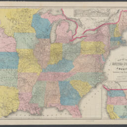
Map of the United States of America showing the railroads : to illustrate Harpers Gazetteer
Permalink
https://digital.library.illinois.edu/items/b0c51080-b51d-013a-c3e8-02d0d7bfd6e4-5
No Copyright - United States
Descriptive Information
| Title | Map of the United States of America showing the railroads : to illustrate Harpers Gazetteer |
| Creator | J.C. Smith & Son |
| Contributor | McLellan, David, |d approximately 1825- |
| Scale | Scale [ca. 1:4,224,000] |
| Coordinates | (W 127°--W 67°/N 50°--N 28°) |
| Place of Publication | New York (N.Y.) |
| Publisher | J.C. Smith & Son |
| Date of Publication | 1855 |
| Extent | 1 map : hand colored, mounted on cloth backing |
| Dimensions | 52 x 67 cm |
| Notes |
|
| Coverage-Spatial | United States |
| Language | English |
| Subject | Railroads |
| Genre | Maps |
| Rights | No Copyright - United States |
| Type | Cartographic material |
| Repository | Map Library |
| Local Bib ID | 99398877712205899 |
| Collection Title | Railroad Maps |
| Collection | Railroad Maps |
Download Options
|
Map of the United States of America showing the railroads : to illustrate Harpers Gazetteer |
Contact us
for questions and to provide feedback.