
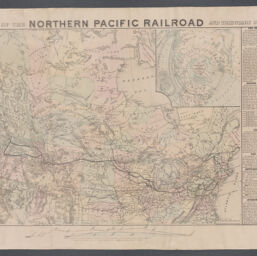
Map of the Northern Pacific Railroad and tributary country
Northern Pacific Railroad
Permalink
https://digital.library.illinois.edu/items/b11b55f0-b51d-013a-c3e8-02d0d7bfd6e4-c
No Copyright - United States
Descriptive Information
| Title | Map of the Northern Pacific Railroad and tributary country |
| Alternative Title | Northern Pacific Railroad |
| Creator | Jay Cooke & Co. |
| Scale | Scale approximately 1:6,700,000 |
| Coordinates | (W 144°--W 65°/N 69°--N 34°) |
| Place of Publication | Philadelphia (Pa.) |
| Publisher | National Railway Publication Company |
| Date of Publication | 1872 |
| Extent | 1 map : hand colored |
| Dimensions | 54 x 72 cm |
| Notes |
|
| Coverage-Spatial | Canada |
| Language | English |
| Subject | Northern Pacific Railroad Company |
| Genre | Maps |
| Rights | No Copyright - United States |
| Type | Cartographic material |
| Repository | Map Library |
| Local Bib ID | 99916719712205899 |
| Collection Title | Railroad Maps |
| Collection | Railroad Maps |
Download Options
|
Map of the Northern Pacific Railroad and tributary country |
Contact us
for questions and to provide feedback.