


Map of land-grant and bond-aided railroads of the United States : 1892
Permalink
https://digital.library.illinois.edu/items/b123db70-b51d-013a-c3e8-02d0d7bfd6e4-f
No Copyright - United States
Descriptive Information
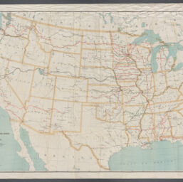
| Title | Map of land-grant and bond-aided railroads of the United States : 1892 |
| Creator | United States. Army. Quartermaster Corps |
| Scale | Scale approximately 1:4,400,000 |
| Coordinates | (W 125°--W 75°/N 52°--N 25°) |
| Place of Publication | Washington (D.C.) |
| Publisher | United States. Army. Quartermaster Corps |
| Date of Publication | 1892 |
| Extent | 1 map : color |
| Dimensions | 66 x 95 cm |
| Notes | Bond-aided roads shown by heavy black lines. Fifty per cent grant roads shown by red lines. Free land grant roads shown by green lines. Connections shown by light black lines. |
| Coverage-Spatial | United States |
| Language | English |
| Subject | Railroads |
| Genre | Maps |
| Rights | No Copyright - United States |
| Type | Cartographic material |
| Repository | Map Library |
| Local Bib ID | 99954864004705899 |
| Collection Title | Railroad Maps |
| Collection | Railroad Maps |
Download Options
|
Map of land-grant and bond-aided railroads of the United States : 1892 |
Contact us
for questions and to provide feedback.