
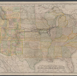
Correct map of the Chicago, Burlington & Quincy R.R. and connecting lines / Rand, McNally & Co., printers and engravers
Permalink
https://digital.library.illinois.edu/items/b1332c50-b51d-013a-c3e8-02d0d7bfd6e4-9
No Copyright - United States
Descriptive Information
| Title | Correct map of the Chicago, Burlington & Quincy R.R. and connecting lines / Rand, McNally & Co., printers and engravers |
| Creator | Rand McNally and Company |
| Scale | Scale approximately 1:3,950,000 |
| Coordinates | (W 125°--W 69°/N 50°--N 24°) |
| Place of Publication | Chicago (Ill.) |
| Publisher | Rand McNally and Company |
| Date of Publication | 1883 |
| Extent | 1 map : color |
| Dimensions | 66 x 112 cm |
| Notes |
|
| Coverage-Spatial | United States |
| Language | English |
| Subject | Chicago, Burlington & Quincy Railroad Company |
| Genre | Maps |
| Rights | No Copyright - United States |
| Type | Cartographic material |
| Repository | Map Library |
| Local Bib ID | 99954925218005899 |
| Collection Title | Railroad Maps |
| Collection | Railroad Maps |
Download Options
|
Correct map of the Chicago, Burlington & Quincy R.R. and connecting lines / Rand, McNally & Co., printers and engravers |
Contact us
for questions and to provide feedback.