


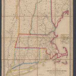
Railroad map of New England & eastern New York compiled from the most authentic sources
Permalink
https://digital.library.illinois.edu/items/b13c4fa0-b51d-013a-c3e8-02d0d7bfd6e4-9
No Copyright - United States
Descriptive Information
| Title | Railroad map of New England & eastern New York compiled from the most authentic sources |
| Creator | Goldthwait, J. H. |
| Scale | Scale approximately 1:700,000 |
| Place of Publication | Boston (Mass.) |
| Publisher | Redding & Co. |
| Date of Publication | 1849 |
| Extent | 1 map : hand color |
| Dimensions | 60 x 50 cm |
| Notes |
|
| Coverage-Spatial | New England |
| Subject | Railroads |
| Genre | Maps |
| Rights | No Copyright - United States |
| Type | Cartographic material |
| Repository | Map Library |
| Local Bib ID | 99955091461205899 |
| Collection Title | Railroad Maps |
| Collection | Railroad Maps |
Download Options
|
Railroad map of New England & eastern New York compiled from the most authentic sources |
Contact us
for questions and to provide feedback.