
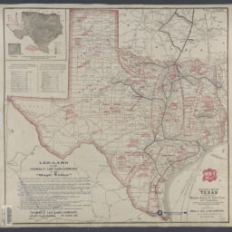
Sectional map of Texas traversed by the Missouri, Kansas & Texas lines and connections : showing the crops adapted to each section, with the elevation and annual rainfall / The MK and T, Missouri Kanasa & Texas Railway ; complements of Thos. F. Lee Land Company
Permalink
https://digital.library.illinois.edu/items/b1448b40-b51d-013a-c3e8-02d0d7bfd6e4-3
eng
Descriptive Information
| Title | Sectional map of Texas traversed by the Missouri, Kansas & Texas lines and connections : showing the crops adapted to each section, with the elevation and annual rainfall / The MK and T, Missouri Kanasa & Texas Railway ; complements of Thos. F. Lee Land Company |
| Creator | Missouri-Kansas-Texas Railroad |
| Scale | Scale not given |
| Coordinates | (W 130°--W 64°/N 52°--N 24°). |
| Place of Publication | Saint Louis (Mo.) |
| Publisher | Thomas F. Lee Land Company |
| Date of Publication | 1909 |
| Extent | 1 map : color |
| Dimensions | 52 x 55 cm |
| Notes |
|
| Coverage-Spatial | Texas |
| Language | English |
| Subject | |
| Genre | |
| Rights | No Copyright - United States |
| Rights Description | eng |
| Type | Cartographic material |
| Repository | Map Library |
| Local Bib ID | 99955091463305899 |
| Collection Title | Railroad Maps |
| Collection | Railroad Maps |
Download Options
|
Sectional map of Texas traversed by the Missouri, Kansas & Texas lines and connections : showing the crops adapted to each section, with the elevation and annual rainfall / The MK and T, Missouri Kanasa & Texas Railway ; complements of Thos. F. Lee Land Company |
Contact us
for questions and to provide feedback.