
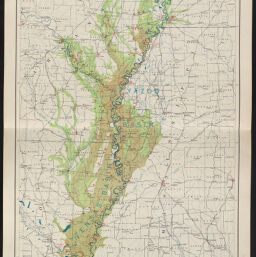
Mississippi river flood of 1927. Showing flooded areas and field operations under Herbert Hoover, chairman of President's Commission and James L. Fieser, Vice chairman of American National Red Cross. Prepared and printed by the U.S. Coast and Geodetic Survey, from data furnished by the Corps of Engineers, U.S. Army
Permalink
https://digital.library.illinois.edu/items/c8917360-66e4-0138-727b-02d0d7bfd6e4-9
No Copyright - United States
Descriptive Information
| Title | Mississippi river flood of 1927. Showing flooded areas and field operations under Herbert Hoover, chairman of President's Commission and James L. Fieser, Vice chairman of American National Red Cross. Prepared and printed by the U.S. Coast and Geodetic Survey, from data furnished by the Corps of Engineers, U.S. Army |
| Scale | approximately 1:844,800 |
| Coordinates | (W 93°--W 89°/N 38°--N 29°) |
| Place of Publication | Washington (D.C.) |
| Publisher | U.S. Coast and Geodetic Survey |
| Date of Publication | 1927 |
| Extent | 1 map |
| Dimensions | 116 x 50 cm |
| Notes | Shows areas covered by first and second floods of 1927, levees, breaks in levees, Red Cross relief camps, Red Cross reconstruction offices, and Red Cross general headquarters. |
| Coverage-Spatial | Mississippi River |
| Language | English |
| Subject | Floods |
| Genre | Maps |
| Rights | No Copyright - United States |
| Type | Cartographic material |
| Repository | Map Library |
| Local Bib ID | 3992300 |
| Collection Title | River Maps |
| Collection | River Maps |
Download Options
|
Mississippi river flood of 1927. Showing flooded areas and field operations under Herbert Hoover, chairman of President's Commission and James L. Fieser, Vice chairman of American National Red Cross. Prepared and printed by the U.S. Coast and Geodetic Survey, from data furnished by the Corps of Engineers, U.S. Army |
Contact us
for questions and to provide feedback.