
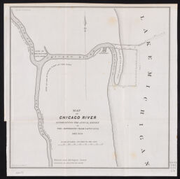
Map of Chicago River, accompanying the annual report of Tho. Jefferson Cram, Capt. U.S.T.E., Sep. 1839
Permalink
https://digital.library.illinois.edu/items/dd4ff4b0-5a68-0139-7734-02d0d7bfd6e4-5
No Copyright - United States
Descriptive Information
| Title | Map of Chicago River, accompanying the annual report of Tho. Jefferson Cram, Capt. U.S.T.E., Sep. 1839 |
| Creator | Cram, Thomas Jefferson, 1807?-1883 |
| Contributor | Stone, William James, 1798-1865 |
| Scale | 1:9,600. 800 feet to the inch. |
| Place of Publication | Washington (D.C.) |
| Publisher | United States. Congress. Senate |
| Date of Publication | 1840 |
| Extent | 1 map |
| Dimensions | 28 x 27 cm |
| Notes |
|
| Coverage-Spatial | Chicago River (Ill.) |
| Language | English |
| Subject | Harbors |
| Genre | Maps |
| Rights | No Copyright - United States |
| Type | Cartographic material |
| Repository | Map Library |
| Local Bib ID | 99954806095405899 |
| Collection Title | River Maps |
| Collection | River Maps |
Download Options
|
Map of Chicago River, accompanying the annual report of Tho. Jefferson Cram, Capt. U.S.T.E., Sep. 1839 |
Contact us
for questions and to provide feedback.