
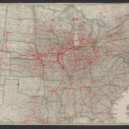
Correct map of the Chicago, Burlington, and Quincy Rail Road and its principal connecting lines / Geo. F. Cram [for] Chicago, Burlington & Quincy Railroad Company
Permalink
https://digital.library.illinois.edu/items/e10d2ce0-2581-013b-c7b0-02d0d7bfd6e4-0
No Copyright - United States
Descriptive Information
| Title | Correct map of the Chicago, Burlington, and Quincy Rail Road and its principal connecting lines / Geo. F. Cram [for] Chicago, Burlington & Quincy Railroad Company |
| Alternative Title | Panel title: Travelers guide, Chicago, Burlington and Quincy, and Hannibal and St. Joseph Rail Roads |
| Creator | Cram, George Franklin, 1841-1928 |
| Contributor | |
| Scale | Scale approximately 1:3,250,000 |
| Coordinates | W 110°--W 69°/N 49°--N 29° |
| Place of Publication | Chicago (Ill.) |
| Publisher | Rand McNally and Company |
| Date of Publication | 1881 |
| Extent | 1 map : color |
| Dimensions | 66 x 92 cm, on sheet 67 x 96 cm |
| Notes |
|
| Coverage-Spatial | United States |
| Language | English |
| Subject | |
| Genre | Maps |
| Rights | No Copyright - United States |
| Type | Cartographic material |
| Repository | Map Library |
| Local Bib ID | 99955200916405899 |
| Collection Title | Railroad Maps |
| Collection | Railroad Maps |
Download Options
|
99955200916405899-001 | |
|
99955200916405899-002 |
Contact us
for questions and to provide feedback.