
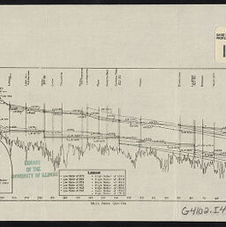
Profile of Illinois River from Grafton to mouth of Kankakee showing water levels, gages & other data : to accompany report of Alvord & Burdick, engineers
Permalink
https://digital.library.illinois.edu/items/e9aa04b0-1291-013a-7af9-02d0d7bfd6e4-0
No Copyright - United States
Descriptive Information
| Title | Profile of Illinois River from Grafton to mouth of Kankakee showing water levels, gages & other data : to accompany report of Alvord & Burdick, engineers |
| Contributor | |
| Scale | Scale approximately 1:1,689,600. Vertical scale approximately 1:349 |
| Place of Publication | Springfield (Ill.) |
| Publisher | Illinois state journal |
| Date of Publication | 1915 |
| Extent | 1 profile |
| Dimensions | 13 x 28 cm |
| Notes |
|
| Coverage-Spatial | Illinois River (Ill.) |
| Language | English |
| Subject | Water levels |
| Genre | |
| Rights | No Copyright - United States |
| Type | Cartographic material |
| Repository | Map Library |
| Local Bib ID | 99399318712205899 |
| Collection Title | River Maps |
| Collection | River Maps |
Download Options
|
Profile of Illinois River from Grafton to mouth of Kankakee showing water levels, gages & other data : to accompany report of Alvord & Burdick, engineers |
Contact us
for questions and to provide feedback.