
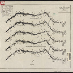
Map of Illinois River bottoms showing levee districts : to accompany the report of Alvord & Burdick, engineers, Chicago
Permalink
https://digital.library.illinois.edu/items/e9aff630-1291-013a-7af9-02d0d7bfd6e4-b
No Copyright - United States
Descriptive Information
| Title | Map of Illinois River bottoms showing levee districts : to accompany the report of Alvord & Burdick, engineers, Chicago |
| Contributor | |
| Scale | Scale [ca. 1:645,000]. |
| Place of Publication | Springfield (Ill.) |
| Publisher | Illinois state journal |
| Date of Publication | 1915 |
| Extent | 1 map |
| Dimensions | on sheet 22 x 70 cm, folded to 22 x 12 cm |
| Notes |
|
| Coverage-Spatial | Illinois River Valley (Ill.) |
| Language | English |
| Subject | Levee districts |
| Genre | Maps |
| Rights | No Copyright - United States |
| Type | Cartographic material |
| Repository | Map Library |
| Local Bib ID | 99399319012205899 |
| Collection Title | River Maps |
| Collection | River Maps |
Download Options
|
Map of Illinois River bottoms showing levee districts : to accompany the report of Alvord & Burdick, engineers, Chicago |
Contact us
for questions and to provide feedback.