
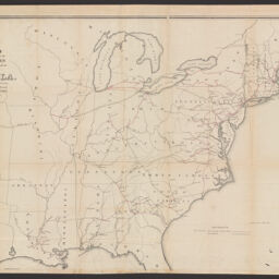
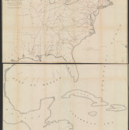
Skeleton map showing the rail roads completed and in progress in the United States and their connection as proposed with the harbor of Pensacola, and its relative position to the various important ports on the Gulf of Mexico, the Atlantic coast and in the West Indies
Permalink
https://digital.library.illinois.edu/items/f0eb5470-8a51-013a-c212-02d0d7bfd6e4-0
No Copyright - United States
Descriptive Information
| Title | Skeleton map showing the rail roads completed and in progress in the United States and their connection as proposed with the harbor of Pensacola, and its relative position to the various important ports on the Gulf of Mexico, the Atlantic coast and in the West Indies |
| Creator | United States. Congress. House |
| Scale | Scale approximately 1:3,400,000 ; Scale of miles |
| Coordinates | (W 98°--W 64°/N 46°--N 6°) |
| Place of Publication | Washington (D.C.) |
| Publisher | United States. Congress. House |
| Date of Publication | 1848 |
| Extent | 1 map : hand color |
| Dimensions | 123 x 92 cm |
| Notes |
|
| Coverage-Spatial | |
| Language | English |
| Subject | |
| Genre | Maps |
| Referenced by | Referenced in: Miscellaneous documents no. 99, page 62. Charts, maps &c. published under the authority of Congress. |
| Rights | No Copyright - United States |
| Type | Cartographic material |
| Repository | Map Library |
| Local Bib ID | 99161846012205899 |
| Collection Title | Railroad Maps |
| Collection | Railroad Maps |
Download Options
|
99161846012205899-001 | |

|
99161846012205899-002 | |
|
99161846012205899-003 |
Contact us
for questions and to provide feedback.