
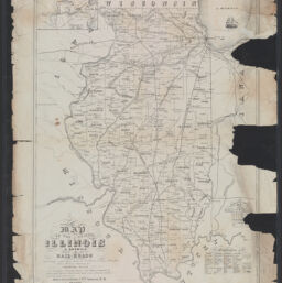
Map of the state of Illinois, N. America showing all its rail-roads completed or in progress connecting with lines direct to N. York, S. Louis & Canada, their stations, distances & : showing also the counties, county towns, post offices, canals & principal rivers, coal and lead mine districts, timber and meadow lands
Permalink
https://digital.library.illinois.edu/items/f1164310-8a51-013a-c212-02d0d7bfd6e4-f
No Copyright - United States
Descriptive Information
| Title | Map of the state of Illinois, N. America showing all its rail-roads completed or in progress connecting with lines direct to N. York, S. Louis & Canada, their stations, distances & : showing also the counties, county towns, post offices, canals & principal rivers, coal and lead mine districts, timber and meadow lands |
| Contributor | |
| Scale | Scale [ca. 1:1,000,000] |
| Place of Publication | Chicago (Ill.) |
| Publisher | Greenebaum, Henry |
| Date of Publication | 1855 |
| Extent | 1 map |
| Dimensions | 63 x 47 cm |
| Notes |
|
| Coverage-Spatial | Illinois |
| Language | English |
| Subject | Railroads |
| Genre | Maps |
| Rights | No Copyright - United States |
| Type | Cartographic material |
| Repository | Map Library |
| Local Bib ID | 99162531012205899 |
| Collection Title | Railroad Maps |
| Collection | Railroad Maps |
Download Options
|
Map of the state of Illinois, N. America showing all its rail-roads completed or in progress connecting with lines direct to N. York, S. Louis & Canada, their stations, distances & : showing also the counties, county towns, post offices, canals & principal rivers, coal and lead mine districts, timber and meadow lands |
Contact us
for questions and to provide feedback.