
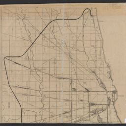
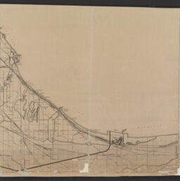
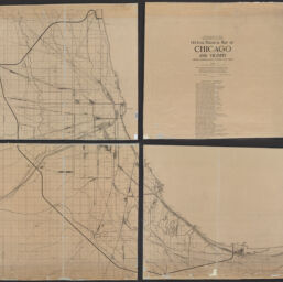
Official terminal map of Chicago and vicinity showing railroad lines, terminals and yards
Permalink
https://digital.library.illinois.edu/items/f11a2ae0-8a51-013a-c212-02d0d7bfd6e4-c
No Copyright - United States
Descriptive Information
| Title | Official terminal map of Chicago and vicinity showing railroad lines, terminals and yards |
| Creator | Chicago Association of Commerce and Industry. Committee of Investigation on Smoke Abatement and Electrification of Railway Terminals |
| Contributor | Burt, Horace G. |
| Scale | Scale approximately 1:32,500. |
| Place of Publication | Chicago (Ill.) |
| Publisher | Chicago Association of Commerce and Industry. Office of Chief Engineer |
| Date of Publication | 1911 |
| Extent | 1 map : dissected in 4 pieces |
| Dimensions | 175 x 187 cm, on sheets 90 x 97 or smaller |
| Notes |
|
| Coverage-Spatial | Chicago Metropolitan Area (Ill.) |
| Language | English |
| Subject | Railroads |
| Genre | Maps |
| Rights | No Copyright - United States |
| Type | Cartographic material |
| Repository | Map Library |
| Local Bib ID | 99162559212205899 |
| Collection Title | Railroad Maps |
| Collection | Railroad Maps |
Download Options
|
99162559212205899-001 | |

|
99162559212205899-002 | |

|
99162559212205899-003 | |
|
99162559212205899-004 | |
|
99162559212205899-005 |
Contact us
for questions and to provide feedback.