
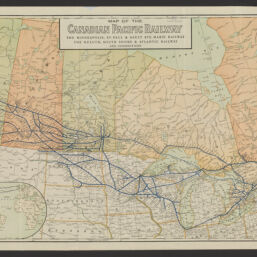
Map of the Canadian Pacific Railway : the Minneapolis, St. Paul & Sault Ste. Marie Railway, the Duluth, South Shore & Atlantic Railway and connections
Permalink
https://digital.library.illinois.edu/items/f11f8530-8a51-013a-c212-02d0d7bfd6e4-2
No Copyright - United States
Descriptive Information
| Title | Map of the Canadian Pacific Railway : the Minneapolis, St. Paul & Sault Ste. Marie Railway, the Duluth, South Shore & Atlantic Railway and connections |
| Creator | Poole Brothers |
| Scale | Scale [ca. 1:47,000] |
| Coordinates | (W 135°--W 55°/N 56°--N 40°) |
| Place of Publication | Chicago (Ill.) |
| Publisher | Poole Brothers |
| Date of Publication | 1914 |
| Extent | 1 map : color, mounted on cloth backing |
| Dimensions | 46 x 112 cm |
| Notes |
|
| Coverage-Spatial | Canada |
| Language | English |
| Subject | Canadian Pacific Railway Company |
| Genre | Thematic maps |
| Rights | No Copyright - United States |
| Type | Cartographic material |
| Repository | Map Library |
| Local Bib ID | 99162825512205899 |
| Collection Title | Railroad Maps |
| Collection | Railroad Maps |
Download Options
|
Map of the Canadian Pacific Railway : the Minneapolis, St. Paul & Sault Ste. Marie Railway, the Duluth, South Shore & Atlantic Railway and connections |
Contact us
for questions and to provide feedback.