
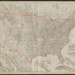
General railway map engraved expressly for the Official guide of the railways and steam navigation lines of the United States, Porto Rico, Canada, Mexico and Cuba : comprising maps of the United States, Cuba, Porto Rico, the Philippines, etc.
Panel title: General railroad map
Permalink
https://digital.library.illinois.edu/items/f1c834f0-8a51-013a-c212-02d0d7bfd6e4-0
No Copyright - United States
Descriptive Information
| Title | General railway map engraved expressly for the Official guide of the railways and steam navigation lines of the United States, Porto Rico, Canada, Mexico and Cuba : comprising maps of the United States, Cuba, Porto Rico, the Philippines, etc. |
| Alternative Title |
|
| Creator | National Railway Publication Company |
| Scale | Scale approximately 1:3,900,000 |
| Coordinates | (W 129°--W 60°/N 56°--N 21°) |
| Place of Publication | Buffalo (N.Y.) |
| Publisher | |
| Date of Publication | 1923 |
| Extent | 1 map : color |
| Dimensions | 96 x 132 cm, folded to 26 x 17 cm |
| Notes |
|
| Coverage-Spatial | |
| Language | English |
| Subject | Railroads |
| Genre | |
| Rights | No Copyright - United States |
| Type | Cartographic material |
| Repository | Map Library |
| Local Bib ID | 99955044657605899 |
| Collection Title | Railroad Maps |
| Collection | Railroad Maps |
Download Options
|
General railway map engraved expressly for the Official guide of the railways and steam navigation lines of the United States, Porto Rico, Canada, Mexico and Cuba : comprising maps of the United States, Cuba, Porto Rico, the Philippines, etc. |
Contact us
for questions and to provide feedback.